The famous Patagonia area of Argentina has some amazing hiking trails, but the best has to be the day hike to Mount Fitz Roy and the Laguna De Los Tres!

This whole hike has beautiful views, and at the end, you get to see Laguna De Los Tres, a beautiful blue glacier lake that sits at the base of Mount Fitz Roy, one of South America’s most famous and powerful mountains.
The Fitz Roy hike is hard because it is long and has a lot of elevation gain, but most walkers will still be able to finish it. Even if you don’t go all the way to the lakes, you can still get great pictures of the mountains from the Fitz Roy Mirador (viewpoint) after a modest amount of hiking from the town of El Chalten.

This trip guide will tell you how to hike the Laguna De Los Tres, what to bring, when to go, how to get to El Chalten, and anything else you need to know before you go.
Fitz Roy Quick Facts
- The distance is 22 km (14 mi). go back
- Gain in altitude: 1,050 m (3,445 ft)
- The final altitude is 1,175 meters (3,850 feet).
- 7 to 9 hours to get back
- Moderate to hard difficulty
Where exactly is Mount Fitz Roy?
The Mount Fitz Roy walk is right next to the small town of El Chalten in Patagonia, Argentina.
Getting to El Chalten
There is no airport in El Chalten, so the closest one for this walk is the small international airport in El Calafate (FTE), which has direct flights from Buenos Aires, Cordoba, Ushuaia, and other places.
The flight from Buenos Aires to El Calafate takes about 3 hours and costs about average for the number of companies that offer it. You can fly to Buenos Aires from either AEP or EZE, the city’s two airports. Skyscanner is a place where you can look for flights to Argentina.
From El Calafate, it takes 3 hours to drive to El Chalten. You can take a bus, a private service, or rent a car to get there. Several companies offer bus service, and buses leave regularly.
What to Expect on the Laguna de Los Tres Hike
The hike to Laguna De Los Tres is an out-and-back trail that is mostly flat, except for a few kilometers of steep walking at the beginning and end.
This is a popular hike, and most people do it in one day. However, there are campgrounds along the trail if you want to stay longer and combine it with the nearby Laguna Torre to make a loop walk.
In the sections below, we’ll talk about what to expect from each part of the Fitz Roy walk.
• Starting The Hike From El Chalten
As soon as you start the Fitz Roy walk, it goes uphill. In fact, most of the trail’s overall elevation gain happens in the first few kilometers.
Along the way, you’ll see some downed trees that make nice places to sit and take a break. There are also kilometer signs that show how far you’ve gone on the trail.
• Las Vueltas River Viewpoint
After about a kilometer of walking from El Chalten, you’ll come out of the woods and see a nice view of the Las Vueltas river.
Here, you’ll get your first great view of the hike, with mountains all around and a river running through the valley below.
Most of the time, the wind in Patagonian is crazy, so you won’t want to stay here for very long. But it’s still a great place to snap a few pictures quickly.
• Laguna Capri
After about 3.3 kilometers of climbing, there’s a split in the trail where you can go to either Laguna Capri or the Fitz Roy viewpoint.
I think you should do the view point on the way up and the lake on the way down. If you want to stay longer, you can also camp at Laguna Capri.
• Mirador Del Fitz Roy Viewpoint
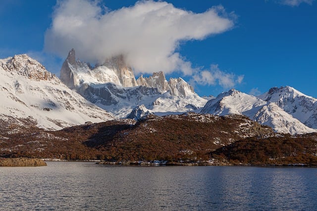
After walking about 4 kilometers (2.5 miles) from El Chalten, you’ll get to the “Mirador Del Fitz Roy” viewpoint, which has some of the best views of the whole trip.
On a clear day, you can see Mount Fitz Roy and the sharp peaks of Patagonia from right where you are. Even though the mountains are still a long way away, they feel so close here! At the lookout, there is a sign that tells you the names of all the mountain tops.
It’s one of the most beautiful things in the world. Here, the only change is that you can’t see Laguna De Los Tres Lake. This comes after that.
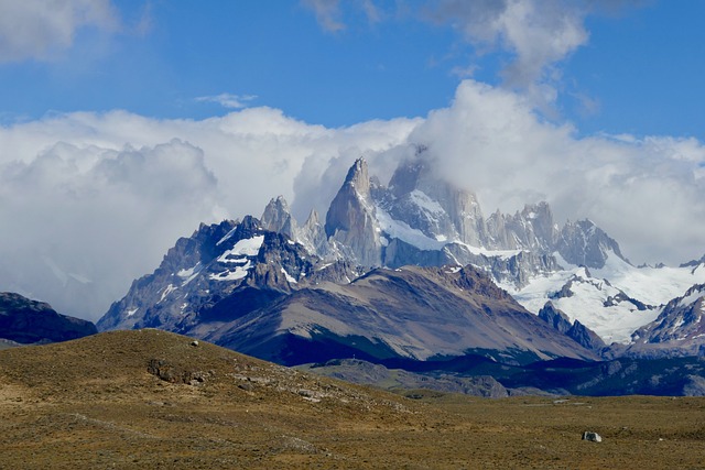
If it’s cloudy, you might not be able to see much from the viewpoint, but I’d suggest you wait until the clouds clear or come back later and try again.
Because of how often the weather changes in Patagonia, I had to go back to the spot a few times before I could finally see the mountains. All the hard work paid off.
This viewpoint is popular with day hikers, but there is plenty of room to spread out and take pictures. It’s a good place to stop and eat or drink something, and there’s a vault toilet in the woods near the opening.
From El Chalten, it takes about 1.5 hours to hike to the Mirador Del Fitz Roy lookout. Overall, it’s wonderful if you want to see great scenery on a shorter and easier hike than going all the way to Laguna De Los Tres!
• Fitz Roy Secret Waterfall
From El Chalten, you can walk about 5.3 kilometers to a short trail that leads to a secret waterfall. On Google Maps and AllTrails, the spot is marked with an icon.
This is a nice little stream with Mount Fitz Roy in the background. To get to it from the main trail, you only have to walk about 150 meters. It’s not likely that you’ll get lost.
Even though summer is almost over, the waterfall is still flowing, and it’s much bigger than it looks in pictures. It’s a great addition to your trek if you have a little extra time and want to take more pictures of Patagonia.
• Fitz Roy Valley To Poincenot
For most of the rest of the Fitz Roy trek, you’ll be going through a flat valley with few or no obstacles or changes in elevation.
This part of the hike is the easiest and, in my opinion, one of the most enjoyable. The road is almost completely flat, so you can just enjoy the scenery of Patagonia without having to work up a sweat.
Along the way, you’ll see ponds, marshes, meadows, and streams going through the valley, and Mount Fitz Roy will always be in front of you.
There are so many places to take pictures here. If you do the walk in the fall, you’ll see a lot of different colors in the leaves, but red and orange stand out.
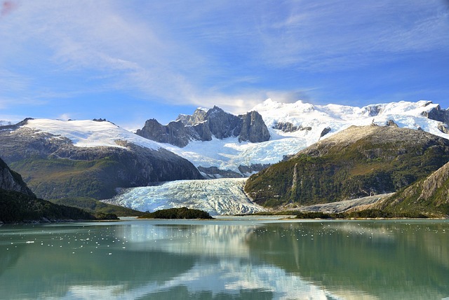
In the distance, you’ll also see another glacier coming. That’s Piedras Blancas. If you have time, you can take a short walk to get closer to it.
The view of the Piedras Blancas glacier from the Piedras Blancas glacier viewpoint adds about 2 kilometers in each way. The path is also mostly flat.
• Climbing To Laguna De Los Tres
After crossing the valley, the climb to Laguna De Los Tres is the hardest part of the Fitz Roy walk.
For the last 2 kilometers (1.2 miles), you have to walk and scramble up a steep hill with loose rocks and gravel. More than 450 meters of vertical gain make it a tough workout.
Near the hill, there’s a sign that says, “Good physical condition required.” I’d say that’s about right. On the way up, watch out for wet, slick rocks.
• Laguna De Los Tres: Lake & Viewpoint
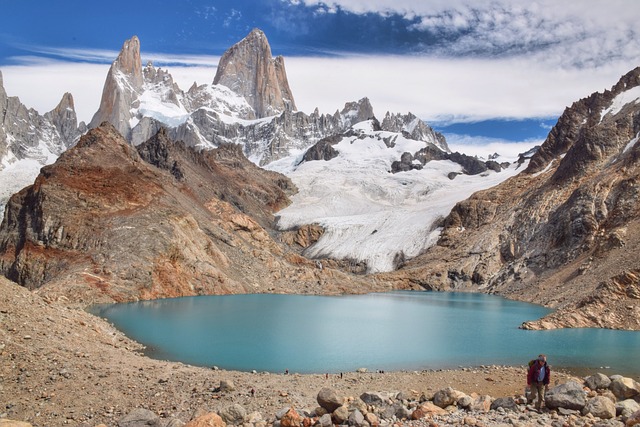
This walk ends at a beautiful blue lake called Laguna De Los Tres. It’s so cool! The name means “Lake of the Three” in Spanish. It comes from the fact that Fitz Roy, Poincenot, and Saint-Exupery are the three mountains that circle the lake.
You can look at the lake from up high, then walk down the hill to get a better look. The melting glacier water gives it a beautiful turquoise color, and there’s a perfect boulder at the lake’s edge where you can stand for pictures.
There are actually two lakes here, but to see the second one (called “Laguna Sucia”), you have to climb the small hill nearby. Don’t forget! From there, you can see both blue lakes, a waterfall, and Fitz Roy right in the middle. Here is the end of the walk.
If you’re curious, only a few people have ever made it to the top of Mount Fitz Roy because it’s very hard and dangerous. The height of the high peak is 3,405 meters (11,171 feet).
How hard is it to hike up Fitz Roy?
The Fitz Roy walk is not hard for the most part. I’d say it was hard or maybe even easy.
For example, climbing to the Fitz Roy viewpoint from El Chalten only takes about 1.5 hours (one way). From there, you can see beautiful views. Up to this point, you’ve climbed about 330 meters (1,100 feet), which isn’t too much. After that, the path is mostly flat and easy until the last climb to Laguna De Los Tres.
I’d say the hike is hard if you go all the way to the lake (Laguna De Los Tres). Even though it’s not dangerous and you won’t be climbing with your hands, it’s a task because it’s long and hard, and the path gets pretty rough at the end.
From El Chalten, it’s about 11 kilometers (7 miles) one way to Laguna De Los Tres. The first and last two kilometers of the hike have a lot of elevation gain, but the rest of the road is mostly flat and easy.
So, in conclusion, Fitz Roy is a great day hike for people of all ages and abilities, and you don’t have to be in great shape to see most of it. However, the last climb to the lakes is hard, and people who don’t walk often might have trouble with it.
What To Carry
Layers: The temperature changes a lot from the start of the path to the last lake, so bring extra clothes. I had a T-shirt, a hoodie, and a light down jacket. Start your walk without the jacket and put it on later.
Gloves: I wore gloves without fingers so I could use my camera and still stay warm enough.
Footwear: For the Laguna De Los Tres hike, shoes with good grip are best. At times, you’ll be walking on slick rocks and up or down steep slopes.
Water: Be sure to bring a lot of water! The first and last few kilometers of the hike are where you’ll need it the most. Stream water on this walk is drinkable, so you can bring less water if you use it. You can also bring a LifeStraw if you want to be extra careful. They don’t take up much space and make the water even safer to drink.
Snacks: I was glad I had brought some food bars and beef jerky from the U.S. In a pinch, you can also bring food from El Chalten.
Powerbank: You might want to bring a small power bank if you want to use your phone to take pictures or as a flashlight. I like Anker because they make tough, high-quality products.
Camera: This hike is full of great places to take pictures! Any camera or lens will work just fine. Fitz Roy is so big that you don’t need a zoom lens to take pictures of it from far away. However, a wide angle lens can be helpful when you get close to it at the last lake.